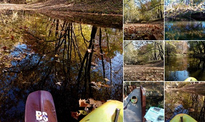
On a sunny fall day a few weeks ago, I hauled my kayak down to the Corp of Engineer’s Calumet Creek (map) access and went for a paddle. It was a nice quiet solo 3 mile round trip with pretty late fall earth tone browns, dark greens, and many falling dry leaves. I saw just a single bright colored tree left hanging over a bend at the creek.
I started by accessing the creek under the foot bridge and paddling inland crawling over one log jam until the creek became too shallow. I turned around, climbed over the log jam again, and paddled back under the foot bridge.
After a sharp bend and under a leaning tree I passed a set of houses. By the look of it, everyone here knows how to fish. Throughout the bend, I would see groups of turtles slipping into the creek off their log perch or mud bank.
Just past here, I paddled under the highway 79 and railroad bridges, through a bottom-land nature reserve, and finally out to the Mississippi River.
I could see 2 river barges, the Lock and Dam #24, the bluffs just north of Clarksville, and the Illinois side. I took in the view, then captured it to share with you.
After a few minutes, I turned around and paddled back the way I came. Enjoy…
- Map of my paddle
- Nearby GORC Cycle Trails
- Nearby GORC Cycle Trail Day Pics


That is such a pretty creek. I have seen wood ducks and huge catfish swimming along from the footbridge. The kayaking looks really fun. I am looking forward to going there when it snows. How gorgeous that will be!
I agree I think I can find another kayak. Maybe you and Sam can join for a winter wonderland paddle.
Love this little adventure! You have a good eye and feel for what’s around you… Nice piece.
Thanks Lex, I’m always glad I got out and did it after it’s done. Add a little blogging pressure, and I stay pretty active. – Mike J