Recovery Fund and Request Supplies

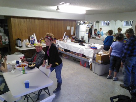
There are some perishables being donated from the kitchen to local families, breads, apples, etc. If you could put it to use, please contact Linda Blakey: 754-0335

The United Fund of Calumet Township has set up a site to accept donations AND REQUESTS for recovery supplies. If you have been affected by the flood and need assistance, please visit the link below to make your request or donation:

http://www.calumetunited.org/wp/2013/04/26/clarksville-flood-relief-2013

The waters are slowly receding and hopefully clean-up will begin soon. The AmeriCorps St. Louis may be available to help clean flooded houses. If you have been affected by the flood, please call a special hotline phone number setup by the City of Clarksville and AmeriCorps:

(314) 478-4846

The kitchen is is slowing down and will be serving breakfast & lunch food most of the day, but no longer serving full dinners.

Thanks to everyone who cooked, but food donations are no longer needed. Please donate through the United Fund of Calumet instead.

The kitchen expects to increase service again when clean-up is more active.

Peak Water

After just 3 days filling sand bags and building the Main St levee, Clarksville has been fighting back peak water for 2 days straight. The rise stalled in the high 34’ level and everyone felt at ease.

But by Monday morning, the water had risen another 1/2’ to 35.35’. The stress on the Main St levee was still increasing, shaking some nerves. Both the North and South side of the Main St levee needed reinforcement. The AmeriCorps team battled the North side wall with sandbag reinforcement, while the National Guard took over the South side with massive loads of new fill.

By 3:00 PM, the reinforcements added enough stability to settle nerves again. Teams began to take breaks, eat for the first time that day, and the bag supply finally began to pile up again. (Inmates from local prisons helped replenish sand bags all afternoon.)

After things settled down, I grabbed homemade food from the Clarksville Methodist Church and finally made my way home.

Clarksville Preparing for Flood

To help: Check-in on Howard Street across from City Hall. They will direct you to where you will be the most help.

Clarksville has been preparing for another historic flood this week. Thank You to all the volunteers both local and non-local. With the help of over 100 people the downtown is preparing for 35+ foot water level, which would crest at the 4th highest level in the history of Clarksville flood recordings.

AmeriCorps has sent nearly 30 members or more into Clarksville. The young adults involved in AmeriCorps have worked non-stop to shovel every pile of sand into 1000s of sandbags. When I left town at 10:00 PM, they were still working alongside many locals with vested and sentimental interest in Clarksville, its history, businesses, and people.

Thank You Everyone.

I am using this site to gage the water level, prediction, and historical reference: http://water.weather.gov/ahps2/hydrograph.php?wfo=lsx&gage=clkm7

Prediction

April 17 High Water Predictions

Prediction

http://water.weather.gov/ahps2/hydrograph.php?wfo=lsx&gage=clkm7

38.1 Sny Island Cell #4 levee is overtopped.
37.5 This is the RECORD FLOOD LEVEL that was reached on July 29 1993.
37.1 Sny Island Cell #3 levee is overtopped.
36.76 This flood level was reached on April 24 1973.
36.25 Highway 79 is closed from one mile south of Annada to two miles north of Annada. Route H is closed from Annada to about one mile west of Annada. Also Route W is closed at Highway 79 in Clarksville for one block.
33.2 IL route 96 near Mozier inundated.
33.1 Route N is closed between Route D and Highway 79.
33 Clarksville city businesses from 1st Street to 3rd Street begin to flood.
31.5 Burlington Northern SF railroad tracks begin to flood. Also, Highway 79 closes one mile south of Clarksville.
31 The Clarksville Boat Club, south of Lock & Dam 24, begins to flood. First Street begins flooding. In Hamburg, Illinois, Water Street floods.
30 East bank (Illinois side) begins to flood. Highway 79 one mile south of Clarksville begins to flood.
29 Water enters the parking lot entrance at the Clarksville Riverfront Park.
27.2 Silo Park just northwest of Clarksville off Highway 79 begins flooding.
25.5 State Route P east of Elsberry begins flooding just east of the levee.
25.3 The road to Port Marmac, about 15 homes just south of Clarksville, begins flooding.
23.5 Flooding begins in unprotected areas
23 At this approximate stage, the Corps will take gates out of the river, creating “open river” conditions. This corresponds to an approximate stage of 155,000 cfs.

The Motor Vessel: Bill Black

Article By Mary Dell Black
Inivte

To honor these two initial Lockmasters on the Arkansas River, the Little Rock District, Corps of Engineers has named two work boats after them, the Bill Black and the Al Workman. The christening of these boats will take place on Wednesday, March 27th near Tichnor, Arkansas.

Bill Black awardIn 1967, Bill Black (better known in Pike Co. as Daddy Bill) left Clarksville’s Lock & Dam 24 to head south to the Arkansas River. After living in Pike Co. since 1918 except for time in WWII, it was to be a new adventure.

He left to become the Lockmaster for Lock # 2 on the newly navigable Arkansas River Project (McClellan – Kerr Water Navigation System). He and a colleague, Al Workman, from the Ohio River would become the first 2 Lockmasters on this newly developed river and together would eventually be in charge of Lock Operations for the 13 locks & dams of the Arkansas River in the state of Arkansas. Daddy Bill became the Chief of Lock Operations for the Dardanelle Resident Office, supervising and training the lock operators on the lock & dam system from Little Rock to Fort Smith. Al supervised the locks on the lower section of the river.

Daddy BillIn Arkansas, Daddy Bill moved as the river moved, and his life followed the openings of the newly constructed locks & dams on the river. In his 7 years there, Daddy Bill lived in DeWitt, AR; Fort Smith, AR; and then Russellville, AR. Throughout his career Bill earned special recognition including a specific Superior Job Performance award for quick and decisive action to avert flooding disasters following heavy rainfalls over the Arkansas River Valley.

In 1974, After 7 years of service to the crews and people of the Arkansas River, Daddy Bill retired and returned to Pike Co. He eventually lived on the hill with a view of the Mississippi where he was able to continue watching the river flow and the towboats run!

Here’s a map of the Lock & Dams of the Arkansas River where Daddy Bill worked:

Pelicans Land in Clarksville

If you were in Clarksville this week, you couldn’t miss the number of pelicans flying around the riverfront. I had my camera with me, so I took a few photos.

You can also spot bald eagles in the trees and air. The pelicans floated south with the current until they were too far from the churning waters caused by the Lock & Dam. Then they would fly up to get close to the dam, and repeat. They were also grouped on the sandbar across the river.